Showing posts with label 14mph. Show all posts

Wednesday, November 16, 2011

Obstacle Course

Zorro with a face full of snow - aaahhhh....
Today's skijoring outing was sketchy at the lower elevations and nirvana at the higher elevations - with a whole Obstacle Course of fun along the way.

We started at the Indiana Creek winter trailhead and skijored up the Indiana Creek trail to the Pennsylvania Creek trail and then up to the high point of this trail. Then a return on the same route.

The Ugly: The first mile was a windblown ice track: very little actual snow with exposed rocks in the worst windblown areas. Slalom skijoring between the rocks on the way up and a "skis off" jog on the way down.

The Bad: The next 1/2 mile was a series of water obstacles: (1) skijoring over a frozen patch of Indiana Creek and hearing the ice crack as we crossed; (2) cruising over the creek on a skinny, one ski width bridge; and then (3) removing the skis to jump over a large exposed portion of the creek to get to the Pennsylvania Creek trail system. The Siberians frolicked in & through freezing Indiana Creek - only the human needed to long jump it. On the return, the same course in reverse: creek jumping, one ski bridge traversing and ice cracking.

The Good: As we crossed out of the Indiana Creek gulch and onto the Pennsylvania Creek trail, we transitioned from windblown terrain into heavily wooded and steep terrain. We immediately got into 6 inches of untouched powder and continued to break trail, all the way up, in powder increasing to 14 inches in depth! Continuing with the "obstacle course" theme, we had 3 downed tree obstacles going up this trail: (1) one small tree across the trail, just slow down and make sure the skis go over & not under; (2) one medium tree covering 3/4 of the trail, just slow down pass through on the narrow 1/4 portion; and (3) one large tree blocking the entire trail (see image below) - necessary to remove the skis and climb over this large obstacle. Of course, the same 3 obstacles on the return path down this trail.

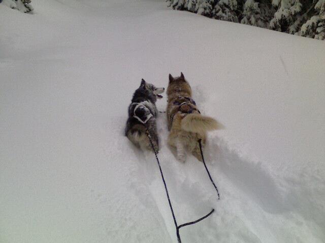
The Incredible: Our route up the Pennsylvania Creek trail traveled about 1.4 miles while climbing 1000 feet in elevation and breaking trail in up to 14 inches of untouched powder - that's a 14% grade in extreme, deep conditions! Woo! Consider that Max & Zorro are under 2 feet tall - they powered me up a 14% grade while breaking trail in 14 inches of deep snow! That's a Siberian workout... Then we got to truck down this same grade, bunny hop sprinting through deep snow - fun, fun, fun...

Vital Stats: 5.7 miles; 100m total time; 65m skijoring time (15m "remove skis, obstacle avoidance" time and 20m jogging down the ugly sections of the trail). 14 MPH top speed; 1300 feet of total elevation gain; breaking trail in up to 14 inches of untouched powder!

We just transitioned from the windblown Indiana Creek trail and onto the heavily
wooded and increasingly deep Pennsylvania Creek trail.
Breaking trail in deep, untouched powder - woo!
Getting Deeper and Steeper - Keep on Truckin!
The worst of the 3 "downed tree" obstacles we encountered.
Wondering, "how will we cross this?" as we approach.
Notice the fun set of wildlife tracks in the snow just in front of us;
wonder if that animal was in the tree when it fell?
Max & Zorro say, "Hey, we can cross just fine over here to the left, let's keep on going!"
Human said, "Sorry fellas, the left isn't skiable - I need to shed the skis and climb over."
Nice shot of our "fresh tracks" coming up through the trees on the
Pennsylvania Creek trail. It was beautiful on this trail, too bad we had
to return ;-)

Thursday, April 14, 2011

Spring Powder Workout

Intersection of Sally Barber trail with French
Gulch trail. About to restart after a slight equipment
adjustment for the human. Max says, "Conditions
are GREAT! Let's GO!!!!"
Wednesday night brought the beginning of a nice Spring snowstorm. Thursday morning found the snow continuing & increasing! Powder day - Max, Zorro & I hit the trails for some skijoring.

The snow was a heavy, wet Spring snow. The depth ranged from 2-8 inches. Moving your body (4 legged or ski legged) through the heavy snow, while breaking trail, is quite the Siberian workout - WOO!

First Section: starting at the Barney Ford trailhead and skiing up to Sally Barber Mine and then down to French Gulch. One set of existing tracks on the way up, breaking trail on the way down, 2-6 inches of heavy, wet powder. FUN!

Second Section: connect with the French Gulch trail after descending from Sally Barber Mine - hang a right and head out & up to the last private cabin in the gulch. Take a break (for the human) and return back down the gulch to the French Gulch winter trailhead. No existing tracks after the first 1/4 mile up the gulch - breaking trail in 4-8 inches of heavy, wet powder. Snowing/blowing hard enough that our "up tracks" were covered almost as soon as we started down - breaking trail again in 4-8 inches of heavy, wet powder. MORE FUN! What a workout.

It is hard to imagine this is the same "French Gulch trail" that left me beaten and battered just 8 days ago. What a difference a little fresh powder has on the dynamics of skijoring!

Vital Stats: 8.0 miles; 2h total time; 1h 40m moving time; 4.8 MPH moving average (while breaking trail in 4-8 inches of heavy, wet snow); 14 MPH top speed; 1,300 feet of elevation gain (and loss).
Beginning the serious part of French Gulch - zero tracks in front of us.
Breaking trail in 4-8 inches of heavy, wet snow.
A glance at the "trail" in front of us. Good thing Max & Zorro instinctually
know how to identify and follow a buried trail :-)
A look back at our tracks from our turnaround point in French Gulch.
About 5 minutes into the return route and our "up tracks" were already
covered in fresh/blowing snow - so it was breaking trail down too!
Still at our turnaround point. Zorro says, "Hold on a sec, I think there
is a Siberian treasure buried in the snow right here!"
Back home and a "zonked out" Max. Spring Powder is quite the Siberian Workout!!!

Saturday, March 5, 2011

Exploring Upper Indiana Creek

Frolicking in the snow as we connected
from Indiana Creek onto Boreas Pass Rd.
Silly human needed a break....
Saturday's fun: breaking trail to extend our Indiana Creek to Boreas Pass skijoring route.

As the season has progressed, all of our original "2 hour" trails have been becoming "well under 2 hour" routes, even as low as 1.5 hour routes. Time to start adding to the routes to get back to 2 hour outings...

The Route: Indiana Creek winter trailhead up to & past the Dyersville junction; continue up Indiana Creek and pass the usual sharp left to ascend up to Boreas Pass Rd; break trail up untouched Indiana Creek until eventually connecting with Boreas Pass Rd; sprint down Boreas Pass Rd to the Boreas winter trailhead.

Our addition to this "Indiana Creek to Boreas" route was to "pass the usual sharp left" - instead we continued to power up & through Indiana Creek, gradually following a long diagonal until we intersected with Boreas Pass Rd. This addition added just under 1 mile to the traditional route - that ought to get us back to a 2 hour tour, we thought....

The Conditions: 2-5 inches of fresh powder from the start to the Dyersville junction; 4-8 inches of fresh powder (breaking trail through 6-8 inches) from Dyersville to Boreas Pass Rd; packed powder down the more traveled Boreas to the winter trailhead.

Vital Stats: 9 miles; 1h 52m total time; 1h 40m moving time; 5.4 MPH moving average; 14 MPH top speed. Under 2 hours again... we need to redesign our routes to be 10+ mile outings ;-)
Heads down, working hard - breaking trail in upper Indiana Creek.
Heads up from the previous shot.
Boreas Pass Rd is somewhere in the foreground (we don't know where/when yet).
No tracks, untouched terrain - breaking trail without hesitation!
Standing on Boreas Pass Rd, looking back at the trail we blazed up Indiana Creek.

Monday, February 14, 2011

Uphill Sprint, Whiteout Gusts, Downhill Anvil

Max says, "Look at the incline! Let's GOOOO!"
Saturday was an interesting skijor day (to put it mildly :-)

- Imagine sprinting up 10-14% uphill grades!
- Imagine 40-50 MPH whiteout gusts of wind!
- Imagine going 14 MPH in a FULL snowplow!
Imagine all 3 of these happening in the same skijor outing!!! Wow...


We returned to the backcountry trails leading to & from Crystal Lakes on Saturday. We did this same expert route back in early December - at that time I discovered Max & Zorro needed more practice to conquer such expert terrain. Well.... 2 months later and WOW - they were incredible, focused, Siberian machines! I was the intermediate and they were the experts. We've skijored the same trails/terrain this winter and I am still advancing out of intermediate whereas Max & Zorro have advanced to extreme expert levels!

It was a very interesting day of mixed terrain and conditions - the highlights:

Leg 1 - Spruce Creek Trailhead to Francies Cabin: packed to packed powder. We took the Crystal Lakes Road path and were at Francies Cabin in about 30 minutes. To truly appreciate this feat you must understand that this section of trail rises over 1000 feet in about 1.9 miles - that is an average of 10% grade - cars have trouble ascending 10% grades! But it gets better... the route has a few gradual sections and even a couple of down dips - so, in my estimate, the steepest parts are easily a 15% grade. We FLEW up this section like racing professionals - I was in awe of my Siberian partners!

Leg 2 - Francies Cabin to Tree Line: 1-3 feet of untouched powder. Not a flinch in my pals - Max & Zorro powering up almost without notice of the depth!

Leg 3 - Tree Line to Lower Crystal Lake: as we approached and surpassed the tree line, the wind gusts started to really pick up. We were skiing head-on into the gusting wind. Each time a big gust blew it approached whiteout-like conditions with all the snow in the wind. Each time a big gust blew Max & Zorro dipped their heads, unphased, and trotted forward into the wind!

Incident 1 - Blown Over: just before reaching Lower Crystal Lake, we paused to readjust and survey the terrain. Max & Zorro were detached at the neck while I was adjusting my equipment (changing to warmer wind gear). I was kneeling over switching gear in my pack when a 40-50 MPH gust of intense blowing snow flew into us. I fell - blown over. Zorro (the smaller of Max/Zorro) was sliding across the slick, wind-blown surface when he hit the end of the gangline - allowing him to get his footing and crawl back to me. He curled at my side as the 2 of us hugged to ride out the whiteout. Max, you ask, well a 40+ "blizzard gust" only served to make him frisky - he was dancing up and down, trying to pull Zorro and I head-on into the direction of the gust! After recovering, getting our bearings and reassembling my pack I heard/saw another gust coming off the peak. I went straight to my knees to brace and Zorro hunkered down at my side again. This gust was even stronger than the first - I looked up to assess Max - I could not see him! The whiteout of the gust was so strong that I could not see Max only 7-8 feet in front of me; but I could feel him pulling on the gangline, once again wanting to take off into the gust and conquer it. Crazy Red Boy!

Leg 4 - the return route: as we started on the return route, a mild 30 MPH gust came up from behind. The wind gave me a boost on my skis and the crazy pair (Max & Zorro) took this as sign that I wanted to GO! Off we flew at extreme speed! What else to say about the down/return route... Remember the fun of sprinting up 10-15% grades? Well, what goes up must come down. I was in a full snowplow most of the way down, trying to keep under control as my extreme expert partners were saying, "Look at this incredible downgrade - wooo, let's FLY!" I now refer to them as the Downhill Anvil - I am just an anchor along for the ride :-)

Vital Stats: 5.8 miles; 2h 10m total; 90m moving time; 3.9 MPH moving average; 14 MPH top speed; over 2,000 feet in elevation gain (and then loss!). The large amount of stopped time was (1) crouching in 40-50 MPH whiteouts, waiting for a break; and (2) constant resting on the way down as my thighs were BURNING from trying to keep us going a sane & safe speed - crazy boys - what FUN!
Approaching Lower Crystal Lake (just over the next hump).
No, my camera is not "fuzzy" - the fuzz is blowing snow as we trekked into the wind abyss.
No, this is not 40 MPH gusts - no way I could even attempt to photograph during those!
Remember the "high point" of the peak in front of us....
Our return approach to the Spruce Creek Trailhead.
Take a glance at my right leg - my right ski is in "more than snowplow" position
as I try to keep the Downhill Anvil under control!
A shot from the town of Breckenridge looking up at Peaks 9 & 10 on the ski resort.
Remember the "peak point" from 2 images ago?
Well, that is the "Peak" labeled in this image!

Thursday, January 20, 2011

Deep Powder Day in French Gulch

Max & Zorro surveying the
surrounding landscape of DEEP
untouched powder!
Monday & Tuesday left over 2 feet of snow in the Breckenridge area. Wednesday we woke to more snow falling - Max, Zorro and I said, "we gotta skijor this big powder event!" So, we headed out to French Gulch Wednesday morning.

Given the ton of fresh snow, we could ski the road to French Gulch before heading into the French Gulch trail system. Thus, we started at the BnB Trailhead skied to & through the French Gulch winter trailhead and up French Gulch to the last of the private backcountry cabins. From here we skied back down French Gulch and hung a left on the Sally Barber Mine trail - then up to Sally Barber Mine and down to the Sally Barber trailhead at the top of the Barney Ford trail (see image below).

The conditions: did I mention we got over 2 feet of snow (with it still snowing as we headed out)? So, there you have it - the conditions: powder, powder and MORE deep powder. From BnB to French Gulch trailhead was a fast, packed powder road; from French Gulch trailhead to the Little French junction was 6-12 inches of powder on established cross country tracks; from Little French to the last cabin was untouched 1-3 feet of pure powder! Wow... The Sally Barber mine section (up & down) was again 6-12 inches of powder on established cross country tracks. That section from Little French to the last cabin was a doozy - so deep that Max & Zorro needed their energy to propel themselves and I had to do a lot more uphill cross country skiing than normal (usually, my Siberian pair propels up and I am lightly skiing - today I was pushing hard as we climbed the powder path)!

Vital Stats: 8.4 miles; 2.5 hours total; 2 hours moving; 4.2 MPH moving average; 14 MPH top speed. Given the deep powder - that's an impressive 4.2 moving average and an amazing 14 MPH top speed!
Starting up after a quick break in the deep powder.
Zorro says, "weeee, let's go bro!"
A look at the "untouched path ahead of us".
We are slogging through 1-3 feet of powder at this point!
A later look at the "path ahead" - still untouched and deep!
The trail goes up the middle of this image and then bends to the right as we get into the trees.
The last backcountry cabin (our turnaround point) is just a short distance from here.

Friday, December 24, 2010

Exploring Dyersville Ghost Town ... Boo!

Zorro says, "this is great!"

Thursday morning found us skiing to explore the historic ghost town of Dyersville.

The town of Dyersville was inhabited in the late 1800s/early 1900s to work the nearby Warriors Mark Mine. Our goal this Thursday morning was to ski, photograph and perceive both Dyersville and the Warriors Mark Mine. Skiing a success... Photos a success (see below)... Ghosts? No - boo!  ;-)

The route was an interesting contrast in terrain.
  1. The first 2.4 miles was a hard packed, uphill & well traveled cross country ski trail - the Indiana Creek winter trailhead up the Indiana Creek trail until the right turn to Dyersville.
  2. The next 0.5 miles was exhilarating! As soon as we turned off the main trail onto the path to Dyersville, we were met with deep & untouched powder - Max, Zorro and I trailblazing the path to & through Dyersville and up to Warriors Mark Mine.
  3. The snow was so deep in sections that I lost "touch with ground" - that is, multiple times I drove my ski pole into the snow to help propel us upwards and my arm & pole drove straight down past my foot, never connecting with solid ground! Yes, that is the length of my arm plus the length of the ski pole in depth and I never connected with solid earth!
  4. The next 0.5 miles was the return (in the same deep powder) from Warriors Mark Mine back to the main Indiana Creek trail.
  5. The last 2.4 miles was, again, the hard packed & well traveled trail to Indiana Creek winter trailhead. Except this direction was downhill (the elevation delta over this section is about 1000 feet)... Hard packed, occasionally steep and attached to 2 Siberian Engines - yikes, this was a test for my intermediate skiing skills!
Vital Stats: 5.8 miles total; 2hrs 5 min travel time; 93 minutes moving time (lots of time stopped exploring Dyersville & Warriors Mark); 3.8 MPH moving average (that 1 mile of deep/deep powder really slowed our average!); 14 MPH top speed.
The first abandoned cabin of Dyersville.
Continuing on to see more of Dyersville.
Those tracks in front of us are RABBIT TRACKS!
A water crossing to another cabin of Dyersville.
Note the narrow "snow bridge" to the left - this was our path over the ice cold, fast running stream.
Starting up from Dyersville to Warriors Mark Mine.
Fresh, untouched and deepening powder!
The narrowing & deepening trail to Warriors Mark Mine.
Warriors Mark Mine.
The snow was waist deep in the "shallow sections" here.
I did not want to get too close to the mine for fear of what I could not see under the snow...

Friday, December 3, 2010

Fresh Snow = Sally Barber Mine Tour

It snowed (lightly) on & off all day Wednesday. My skijoring pals and I were looking for a good hour of exercise on Thursday.

Fresh snow means French Gulch Road is skiable (early morning before the plows & sun do too much damage).

An invigorating hour tour after fresh snow has Sally Barber written all over it. So, B&B trailhead up to French Gulch trailhead up to Sally Barber mine and down to Barney Ford trailhead was in order for Max, Zorro and I!

The Vital Stats: 4.6 miles, 54 minutes, 5.2 MPH average, 14 MPH top speed.  Pure Siberian Fun!

Wednesday, November 17, 2010

Sally Barber Mine Tour

The incredible November snow continues (2 feet in some areas). We did a short, 1 hour tour of French Gulch and Sally Barber Mine on Monday.
Sally Barber Mine (at the high point of Sally Barber Trail)

The Route: Started from the B&B Trailhead on French Gulch Road; skied up French Gulch Road to the French Gulch Winter Trailhead; continued on French Gulch Trail; veered right onto Sally Barber Trail; skied up to Sally Barber Mine; skied down to the Barney Ford Trailhead on Sally Barber Road.
The Vital Stats: 4.6 miles; 57 min tour (53m moving); 5.2 MPH moving average, 14.2 MPH top speed.

French Gulch/Sally Barber Route: BnB Trailhead through French Gulch Trailhead to Sally Barber Trail through Sally Barber Mine and to Barney Ford Trailhead on Sally Barber Road.
  • After a significant snow, French Gulch Road is skiable. it is a dirt road with the only real winter traffic being those driving to the French Gulch Winter Trailhead.
  • The initial down slope from Sally Barber Mine, when attached to 2 Siberian Huskies, is a doozy! I was in a 14 MPH snowplow to keep under control! FUN!
Taking a Break at Sally Barber Mine.
1) Yes, Max's head seems to always be buried in the snow during our breaks!
2) Yes, Zorro is eating snow off the fence for his "water break" :-)

A blast! Here's hoping the November snow continues!